I’ve been thinking a lot about the economic impact of the towpath lately, and have been looking to the Great Allegheny Passage as a model, where many food and lodging places have popped up to cater to the cycle touring crowd. I know that the D&L Corridor people are also looking at various businesses and how the towpaths might impact them, but I believe that they are looking at it from a county-wide perspective, when they should probably really be looking at impact within a few blocks of the path, and or at least within about a mile of the river — would you decide to take a fully loaded touring bike miles out of your way, and probably up some hill to get away from the river, just for say, lunch, if you didn’t absolutely have to? So, that got me thinking about the question: what restaurants, hotels, bike shops, and other amenities are actually within a mile of the relevant sections of the Delaware and Lehigh Rivers?
(This was a good first approximation, but it’s surely a naive way of looking at the problem, since there are many places within a mile of the river as the crow flies, that are not actually within a mile, or maybe even many miles, of anyplace accessible from the towpath — and places that will see towpath business will need to be located within a matter of blocks, not miles, from towpath access points. But I realized all that later as I thought more about the overall situation, and my first analysis of towpath business prospects was what I worked on first.)
The way I looked at it, my original problem broke down into two parts. First, what is the region within one mile (or whatever distance) from the river, and second, what are the amenities within that region? The first part was fairly straightforward, but the second, which looked like it would involve some kind of Google Maps search — and eventually it did — turned out to be more complicated than I thought…
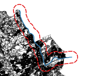
I used QGIS to deal with the first part. I took as my reference some Pennsylvania aerial photos, plus a property map of Lehigh County, and created a new line vector (in a projection that uses feet as a unit of measure), following what looked like the middle of the Lehigh River from about Laurys Station to just past Bethlehem, and then I used the “Create Buffer” geoprocessing tool to create a vector polygon buffer region around that section of river, whose distance from my line vector was 5280 feet, in other words, one mile. That part worked great, but what to do with my buffer region?
My first thought was to take the buffer vector and export it to a KML file, import that KML file into a custom Google Map (using Google’s “My Maps” personal map creation/editing feature), and then “do something” with it. That all worked great as well, up until the “do something” part — the KML file, and the personal map, were not much use when it came to customizing a map search.
I did find online, however, that there were some things you could do with polygonal regions, and testing locations (such as the ones returned from search results) to see if they fell within those regions, using the Google Maps API. This added two new steps: first I had to re-export my buffer region, this time as a GeoJSON file because that was what the API would accept, and I also had to sign up for an API key from Google Maps. Both of these were also straightforward and easy to do.
The final step was to put it all together: make a web page, and (with some javascript), load and draw the GeoJSON file, run a search (for restaurants, in my experimental code), and then find and display results that fell within my region. Code code code, give it a try… nothing. I was able to load the file and see my region, but no place results would be displayed.
Turns out, there is more than one Polygon type in the API, and the one created by loading a GeoJSON file is different than the one you can test locations against; I would have to convert my polygon from one form to another. (This seemed to me a bit much, especially since I thought I should have been able to load the original KML file and it would “just work.” After all, isn’t KML a Google thing, and kind of a standard?) No matter, the conversion process from one polygon to the other looked as straightforward as every other step so far, so I just added it to the end of the task chain. Code code code, give it a try… nothing, and here is where it started to get really frustrating.
I couldn’t for the life of me figure out what was going wrong, it looked like I did things exactly the way I was supposed to but my new, converted polygon could not be made, and it looked like the original polygon actually was empty, even though it was drawn on screen. I eventually used a callback routine from the GeoJSON loading function to get the polygon coordinates, and for some reason that worked.
That gave me my clue: the “some reason” was that the callback was not executed until after the file was done loading, so the conversion routine had something — a non-empty original polygon — to work with, while in my original code the rest of the script wouldn’t wait for the file to finish loading before continuing, so there really was nothing to work with yet when I tried to do the conversion. That took three paragraphs to write, but more than a day to work out…
I didn’t really like my solution: if you’re forced to use callbacks like that, you end up going down the rabbit hole, callback after callback after callback, just to get some semblance of sequential execution. (Meantime, I found that some methods did not suffer from these kinds of problems, they seemed to wait for the data to load before trying to work on it. Strangely enough, all the simple API examples I found at Google used these methods instead of the one I needed.) Eventually I set up a wrapper function to hide the messy details and just get me my goddamned polygon from the goddamned GeoJSON file.
Anyway, here is my demo map:
UPDATE (7/26/2018): This map will stop working after July 30th, because the “radar search” function (see script below) has been deprecated by Google Maps. I may take some time to update the script — which I’ll mark with another update — but then again I may not, because this is a low-usefulness, low-visibility, low-priority thing for me, and also because fuck Google.
And here’s my script. Most of this is based on Google Maps API examples, but the function getBuffer() loads the data, and createBufferPolygon() is the wrapper that creates the polygon object:
  var myNewMap;        // the google map
  var myPlaceService;  // object for google places api
  var myBufferPoly;    // the polygon that holds the buffer region
  var myInfoWindow;    // info window for the selected place

  // the callback function from loading the API, where everything actually happens
  function initMap() {
    myNewMap = new google.maps.Map(document.getElementById('map'), {
      center: {lat: 40.672628, lng: -75.422778 },
      mapTypeId: google.maps.MapTypeId.TERRAIN,
      zoom: 11
    });

    var bikeLayer = new google.maps.BicyclingLayer();
    bikeLayer.setMap(myNewMap);
    myBufferPoly = createBufferPolygon(
      'lbuf2.geojson',
      'lehigh',
      myNewMap,
      true,
      'green'
    );
    myPlaceService = new google.maps.places.PlacesService(myNewMap);
    myInfoWindow = new google.maps.InfoWindow();

    getSearch();
  }

  // this is the wrapper function, which calls the function that loads the GeoJSON file
  // after creating the polygon to hold the buffer region
  function createBufferPolygon(url, featureName, map, isVisible, polyFillColor) {
    var bufPoly = new google.maps.Polygon({
      map: map,
      clickable: false,
      visible: isVisible,
      fillColor: polyFillColor
    });
    getBuffer(url, featureName, bufPoly);
    return bufPoly;
  }

  // this function loads a GeoJSON file containing a named polygon
  // then adds it to the given polygon object
  function getBuffer(url, featureName, poly) {
    var bufGeom;
    var bufferData = new google.maps.Data();
    bufferData.loadGeoJson(
      url,
      {idPropertyName: 'name'},
      function(featarr) {
        bufGeom = bufferData.getFeatureById(featureName).getGeometry();
        poly.setPaths(bufGeom.getAt(0).getArray());
      });
  }

  // finds all restaurants within 15km of a certain location
  function getSearch() {
    var request = {
      location: {lat: 40.703117, lng: -75.416561 },
      radius: 15000,
      keyword: 'restaurant'
    };
    myPlaceService.radarSearch(request, displayResults);
   }

    // displays search results that fall within the buffer region
    function displayResults(searchResults, searchStatus) {
      if (searchStatus !== google.maps.places.PlacesServiceStatus.OK) {
        console.error("getSearch error: " + searchStatus);
        return;
      }
      for (var i=0, result; result=searchResults[i]; ++i) {
        if (google.maps.geometry.poly.containsLocation(
          result.geometry.location, myBufferPoly)) {
            addMarker(result);
          }
        }
      }

  // adds marker for selected places
  function addMarker(place) {
    var marker = new google.maps.Marker({
      map: myNewMap,
      position: place.geometry.location,
      icon: {
        url: 'http://maps.gstatic.com/mapfiles/circle.png',
        anchor: new google.maps.Point(10, 10),
        scaledSize: new google.maps.Size(10, 17)
      }
    });
    google.maps.event.addListener(marker, 'click', function() {
    myPlaceService.getDetails(place, function(result, status) {
      if (status !== google.maps.places.PlacesServiceStatus.OK) {
        console.error(status);
        return;
      }
      myInfoWindow.setContent(result.name);
      myInfoWindow.open(map, marker);
      });
    });
  }
That’s a lot of work for something that solves the wrong problem! My next look at this will likely just involve finding the access points, and doing Google searches near each one — soooo much less elegant…

Pingback:Experiments in Routing, Part 1 – The Other Don Kelly