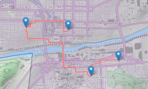
I thought this would take so much longer… I have a web map designed and working, and I was able to add generic routing functionality to it (via the Leaflet Routing Machine plug-in). Here’s a screenshot:
The actual routing engine on the server side is done with PostGIS/PgRouting, accessed through a PHP script — Leaflet Routing Machine does not normally work with PostGIS, but I found another plug-in (called lrm-pgrouting), which included a PostGIS function and some Javascript, to add this functonality. Unfortunately, the unmodified lrm-pgrouting plug-in requires something called Geoserver (rather than just a plain old PHP script) to talk to PostGIS, but it was easy enough to modify the plug-in to use PHP, and writing the script itself was the easiest part of the whole thing.
Once I got routing up and running, I came across a few problems, mostly with how the directions are displayed: the display only showed street names and distances — that is, no turn information — and, for wherever the route continues straight on the same road through an intersection, there is an unnecessary instruction to “go straight.” Both of these were due to errors in lrm-pgrouting which I managed to fix to my liking.
So, success! But this is using a generic routing function, rather than the “climbing vs busy road vs recommended commuter routes” function I ultimately want to use, so there’s some room for improvement. I also think I may want to abandon the Leaflet Routing Machine and do the input and display on my own. Also also, all this stuff currently resides only on my laptop; I have to find a host that will let me run a PostGIS database (among other things). I still have some work to do.
