From Hays , Kansas to be exact — a college town on I-70 in the western part of the state, some 50 miles north of Dodge City (where tonight’s bartender was from originally). It’s our third night out from home, on the way to Denver to visit Emmi & Kyle. We stopped in Yellow Springs (technically, Springfield) OH, and O’Fallon MO (just west of St Louis), and tomorrow night we should be in Denver. Woooo!
-
-
Old Paint, Like The “Mary Ellen Carter”
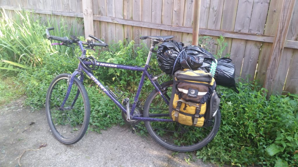
I finally made good on the promise I made to Anne, to my brother-in-law Ray — to anyone who would listen, really — to get a new headset for the Iguana, after that bike-pukes-ball-bearings debacle at Mauch Chunk Lake. I ordered the headset (from Saucon Valley Bikes) last week, brought the bike in a few days ago for them to install it, and picked it up this afternoon. I haven’t done a test ride yet, but it feels great.
Once I got it home I took apart the rear grip shifter and lubed it, and replaced the shifter cable and housing while I was at it. This took longer than I expected, since I forgot how to work with grip shifters, but eventually it all came together — I have now resolved two decade-old problem areas.
Right in the nick of time too, because next week I’m back to the Road Scholar tours, and the Iguana is my go-to bike for these rides because it can carry panniers.
-
An Empire Rebuilt
Now that I have my new Garmin device, I’ve been thinking of picking up where I left off with that ride database and viewing project, which I haven’t touched in months. So imagine my surprise when I go to open Eclipse, my IDE of choice for just about all things coding, and it’s missing!
I have no idea what happened. Sometime between about March and yesterday it deleted itself from my machine — maybe some other program deleted it, or maybe I did it myself without realizing, but bottom line: it was definitely gone. I checked, and the data/programs I’d been working on were still on my machine (whew!) so all I had to do was re-install the program…
It turned out not to be so simple: the latest versions all require 64-bit systems (my dinosaur of a laptop is 32-bit), and the version provided in my outmoded distribution (Linux Mint 17) was far older than the one I had previously installed. Luckily I found, buried in my archives, the program installer for my previous version. I ran that, which gave me a bare-bones installation, and then I started adding on the other modules I used to use. After that came all my personalized configurations… It took a while to get things back to what I think I remember my old system looked like, but everything seems pretty normal again now.
I’m not ready to start messing with the code just yet, but it’s a big load off my mind to know that my setup is back in place.
-
Readings
I brought two books along on
vacationour travels: Jeffery Pomerantz’s little gem Metadata, and Mountains Piled Upon Mountains, a collections of stories, poems and essays about nature in the Appalachians. I finished Metadata yesterday, which was a quick re-read, and started Mountains last night.Whoo, what an intense book! I’ve always found Appalachia — people, places, plants and animals — to be deep: primal, spooky and beautiful. These writers obviously feel the same way, and are more than capable of evoking the feeling in their work. I’ve had to read it in little sections…
Meantime, my sister-in-law just finished the third book of the Cormoran Strike mystery series (by Robert Galbraith, aka J.K. Rowling). There are four books in the series; I read the first three over the past few weeks and Anne has the fourth on Kindle so I may check it out. It may be a while though, since I burned myself out with the first three: the first two were page-turners, but by the third — which was also a lot creepier than the others — I was spotting some plot formulas and other common bits that kind of detracted from the story, and struggled to finish. Still, they were all pretty good books.
-
On “Vacation”
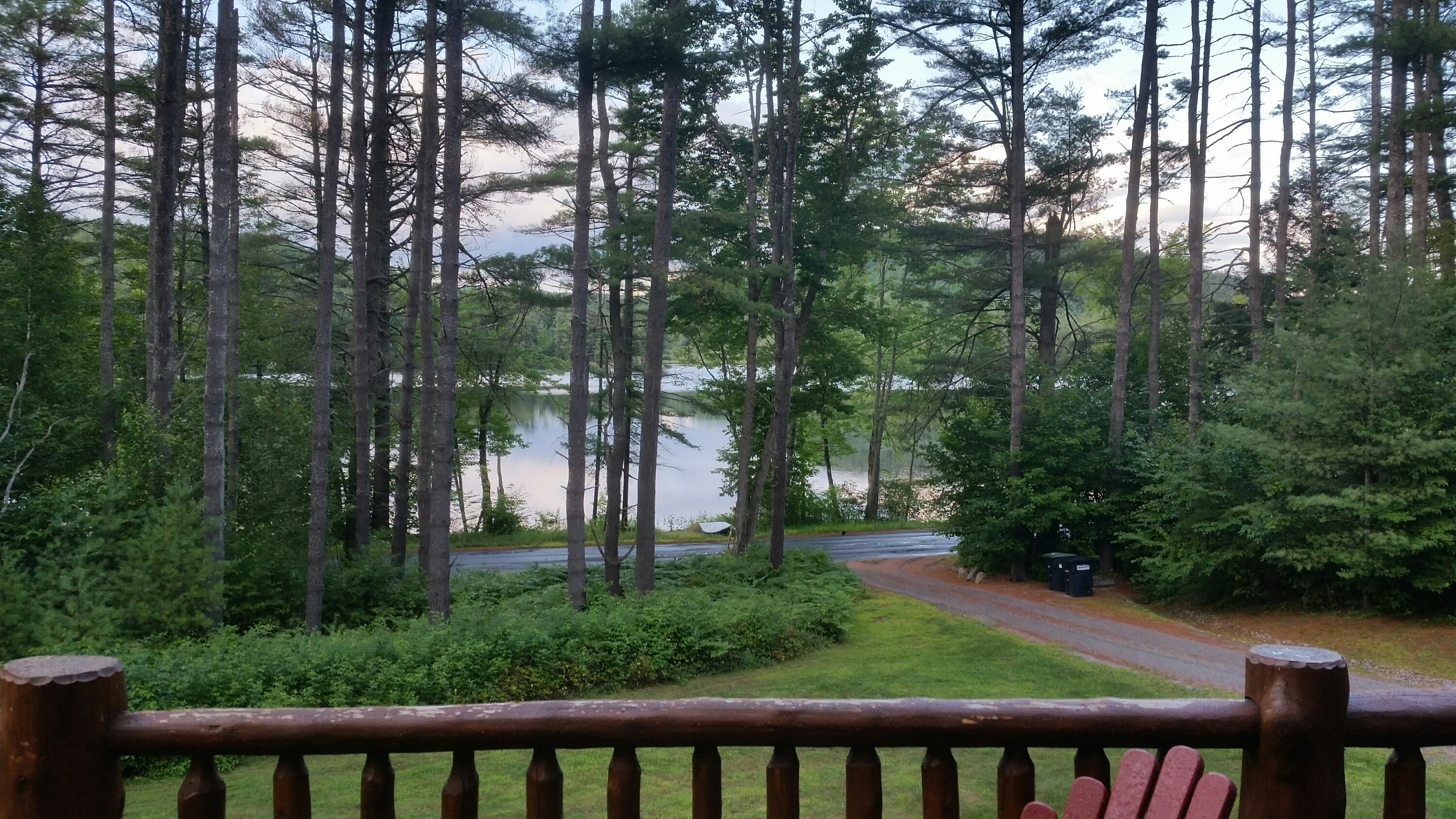
The View From This Year’s Porch Can you still call it vacation if you’re retired? Well here we are, in the Adirondacks again, where we have decided to say we are “traveling.”
-
Some Bearing On The Situation
So the week before last, Anne was on a self-supported bike tour with a few of her friends, Albany to here. They made great time and the ride ended sooner than expected, so she put together another ride, and I went along… We went with our friend Kellyn and did a three-day tour, a sort of triangle: from home to Jim Thorpe via roads and towpath, Jim Thorpe to Anne’s sister’s house in Tamaqua, and home via the towpath again. I have no touring-specific bike, so I rode my trusty old Iguana, which may need some bike-maintenance love but does have a rear rack.
Old Paint Rides Again We started Thursday morning about 8:00, just after Kellyn got to our house. Our route took us up toward the south side of Blue Mountain, then over to the river, via the back roads near Point Phillip and Danielsville, before we picked up the D&L at the Lehigh Gap Nature Center. We rode the rest of the way to Jim Thorpe on the trail, but had to do a bit of bushwhacking in totown: the Mansion House Bridge is scheduled to open tomorrow, but it was closed to all traffic last week. No matter, we got into town and had a huge lunch/dinner (with a few beers) before the final leg — all uphill — to our campsite, right on the shore at Mauch Chunk Lake. Our camp was fairly spartan (no fire, very little food), but we didn’t care: we took our showers and were asleep before the sun was down
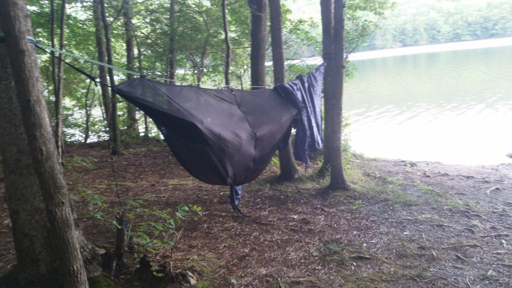
Lakeside Camping Hammock Friday we got an early start for Tamaqua, but before we got too far my bike was making the most horrible squeaking sound. It happened every time I turned the handlebars, and I concluded that the problem was in the headset; we stopped, I turned the bike over, and saw (through the spot where the bearing seal should have been) that the bottom bearing was exposed, and bone dry, and most of the balls had fallen out — there were only two ball bearings still in the race, sitting there like lonely buck teeth in an empty mouth. Uh oh…
I packed a bunch of thick lube into the bearing, tightened it down and hoped for the best. The squealing was gone, and I figured I could at least limp the rest of the way to our destination; I was stressing though, and when we got into town and stopped at a coffee-less “cafe” I managed to leave by Camelbak behind… This was the shortest leg of our trip, but it was starting to feel like a loooong day. But we continued on, grabbed some lunch at Heissler’s Dairy Barn, and then all of a sudden we were at our destination. A quick (and very welcome and refreshing) dip in the pool, then Ray drove me back into town, where we bought some beer, retrieved my Camelbak, and stopped at the bike shop to get some grease and ball bearings. Back to the house, where it was a surprisingly simple matter to pop some balls back into the bearing — this was my greatest “MacGyver” moment ever — and I could finally relax and enjoy the afternoon. This was awesome because Lorraine and Ray had prepared us a feast, and Lori & Chris came over — and when it started to storm, they put us up at their place for the night. We were living in the lap of luxury!
We got up the next morning just before dawn, and went with Lori & Lorraine to walk through a nearby field of sunflowers just as the sun came up. It was a misty, overcast sunrise, but still very beautiful.
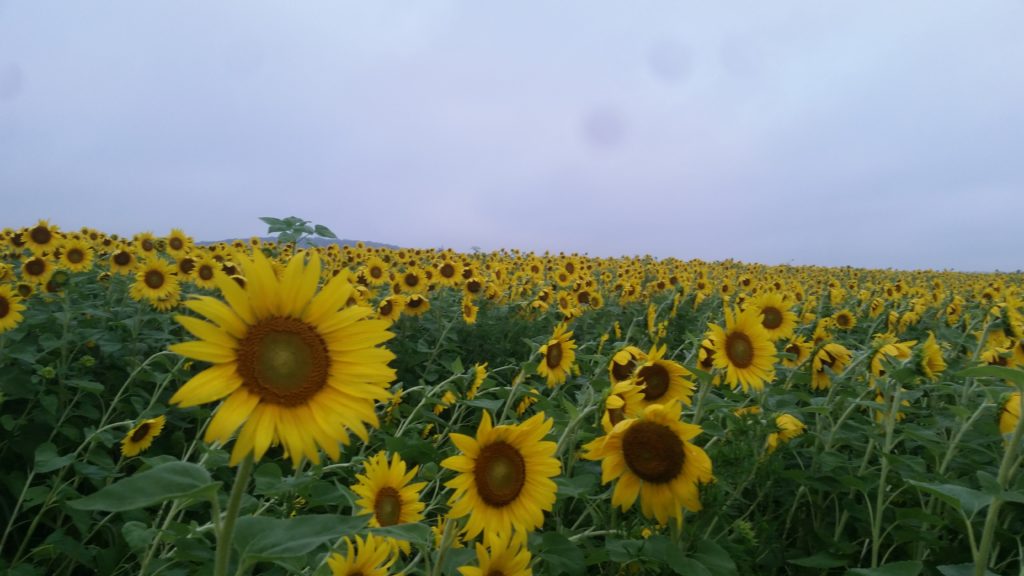
Morning Sunflowers We were back on the road before we knew it, and had a long, and beautiful, but thankfully uneventful, ride back home — and that was that! Three days, 113 self-supported miles over mixed road and trail, good company and some beautiful scenery. I got home and took a “nap” that lasted until the next morning.
-
When Darwin Met Pavlov
I’ve been embedding too many rides lately so I won’t post the data, but I did two rides at Nox this weekend and I learned something about my new Garmin: it beeps when you get air.
Friday night I was out once again with John and Renee, along with Scott & Erin and Heckler Mike, for a “happy hour” ride. We started at the boat launch parking lot, basically rode most of the place in the opposite direction I’m used to, but then again that was the first time I’ve been there since 2017 so it was all like new… Some trails had new (to me) flow sections, with bermed turns and little jumps, and I managed to get some pathetic air on one — and my Garmin chirped at me!
We all went back to J&R’s place for beer & burgers afterward; it was a later night than I expected but when I got home I confirmed it: the sound was because of a jump, and the jump location and stats were all recorded with the ride data.
Saturday’s wake-up was a little rough, but there I was, back at Nox for a morning ride with my friend Ted. We were joined by a friend of his and did a brisk-but-not-crazy standard loop — it was a hot day and I was tired, and I think they took pity on me.
When we got to the little dirt jumps I did some cautious experimenting and got three more beeps out of the Garmin… I think I’ll need to keep a tight rein on this, otherwise I’m going to hurt myself chasing that bell.
-
In the Heat of the Moment
So, Friday night last weekend, we were at the Velodrome with John and Renee, when Renee says “Hey Don, I’m racing at Michaux this Sunday. Want to race the 10 mile course with John?” After a bit of waffling I said yes I’d join them, so last Sunday we rode out to Big Flat and did the Curse of Dark Hollow. (Later I found that Jon had no intentions of going, it wasn’t even on his radar until I said I’d go.)
It turned out to be the hottest day in a multi-day heat wave, temperatures in the high nineties. Standing around in direct sunlight was unbearable, but things were OK in the shade of the trees with a slight breeze blowing, while we waited for the start, and the race itself was fine.
Renee did the 20-mile course, and took off about a half hour before us, then John and I lined up at around 10:00. John rode hard from the start, but I really didn’t feel much killer instinct, even when I ended up towards the back of the “rumba line” of cyclists struggling through the first rocky singletrack. It was just good to be back on that Michaux stone, especially once the field spread out a bit and I could ride without interference. (I even saw a few Allegheny mound-builder hills.) Team Terrapin’s “start slow, then ease up” was my mantra, though I started pushing a bit later…
The last time I raced at Michaux (eight years ago?), I lined up next to a guy in my age group, who looked a bit like John Bolton and who seemed (at first) to just be an officious blowhard: he basically commandeered the race director’s speech, with “let’s thank the race promoters!” and “let’s hear it for the Vet racers!” and we all clapped dutifully, but then he started with some serious TMI about aging and his privates — “amirite fellas? Give a shout out!” — completely oblivious while the applause died away to an uncomfortable silence. He took off like a rocket when the race started, and that was the last I ever saw of him.
Until Sunday, and there he was! I recognized him first during registration, then he was lined up with us for our race. He started with the blowhard stuff again during the pre-race meeting, but the director shut him down (politely, but firmly). I could hear him shouting somewhere ahead of me in the first singletrack, likely berating riders that were in his way, and I caught up with him at the water station.
I had plenty of my own water so I didn’t spend much time at the stop, and I got out of there before he did. The next section was a 3-mile long climb on a Forest Service road, and while I don’t have the fitness I once did, I took this smooth hill as an advantage I could press against “TMI guy,” as I started calling him. Up the hill and back into the woods, where I was now dying and getting passed by people I dropped a while before, and then I got to the finish line. John beat me, but hey I beat TMI guy!
The promoters provided bag lunches, water and a keg of beer, and John and I hung out in the shade with other riders eating our lunches; Renee finished and joined us (she looked like death, which is probably how we looked a half hour earlier) and we stuck around for the awards ceremony — Renee took first place among the 20-mile women.
Anne and I went to Valley Vivaldi that night, and it was all I could do to stay awake…
-
Northeast Kingdom
Well, as it turns out, I didn’t take many pictures, but I do have some stories…
Joe (Anne’s brother) and I drove up Saturday, starting around 6:30 and arriving just about 3:30 at the cabin. Joe’s friends had already arrived, one carload early enough to go out for a ride, so us remaining four got ourselves together and hit the trails, which were literally right across the street.
We did a little riding around, entering the trail system at Coronary and doing the Troll Stroll, one of the nearby black-diamond downhills, then climbing up some steep doubletrack to our starting place, where we managed to connect with the other two members of our group. The six of us continued to explore that part of the system, bombing down several other, very similar trails — smooth, steep and swoopy, with banked turns and names all starting with a “T” — and looping back up to where we started. It was a blast, but those guys were all strong and fast, and it was a hard ride — we regrouped fairly often, but I had trouble keeping them in sight both uphill and down. We basically worked out all the kinks from our long drive, got in a day’s worth of riding and, when the afternoon started getting on we made our way back to the cabin.
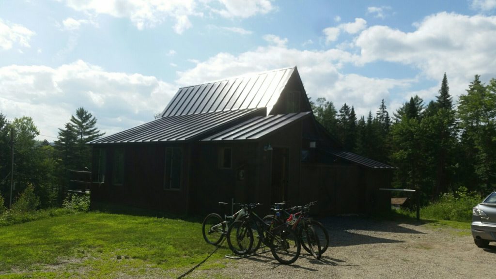
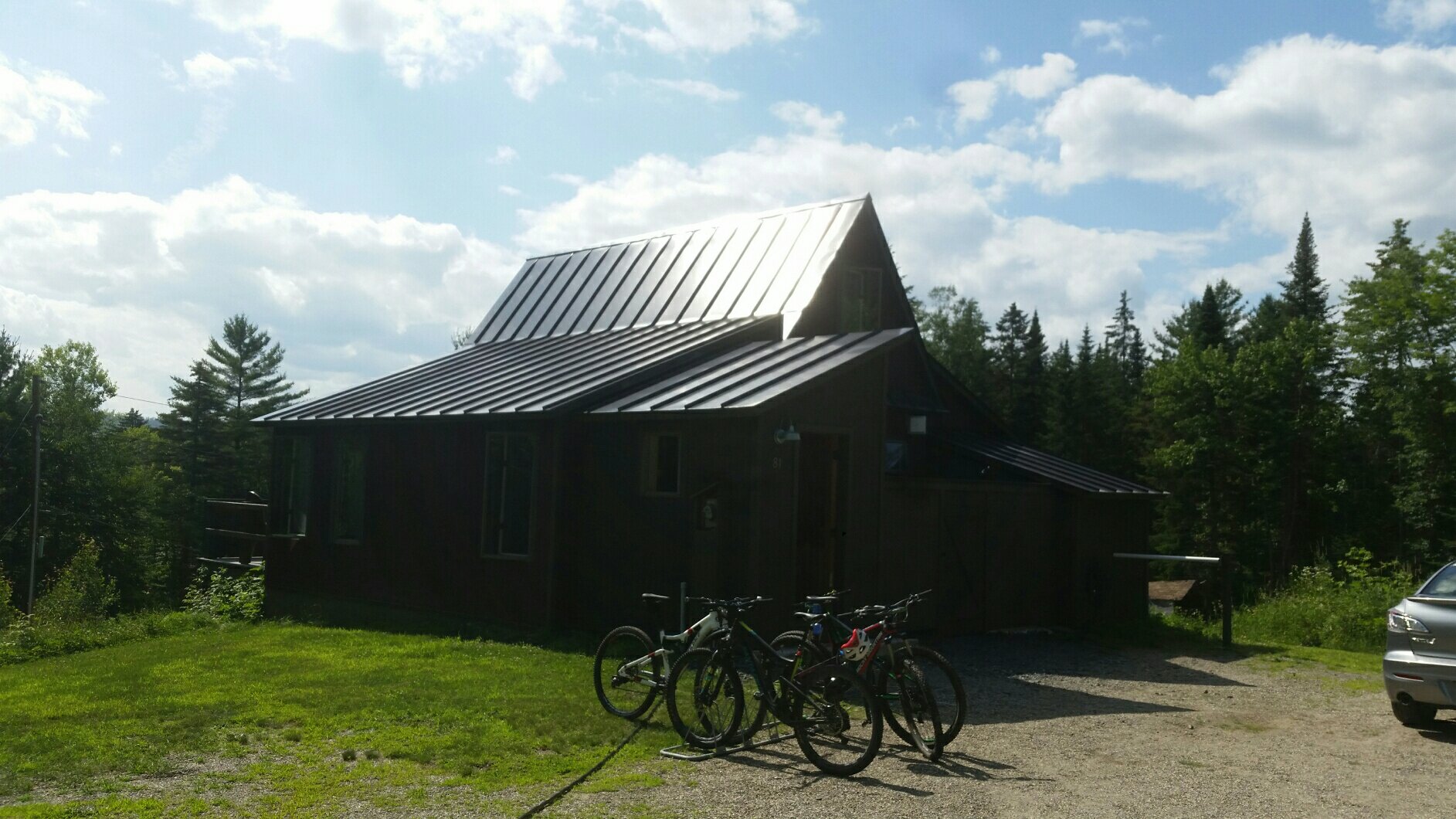
Razzle’s Cabin in the Northeast Kingdom This (Razzle’s Cabin) was perfect: it was cozy and compact, but it was also roomy enough for all of us — it said “sleeps five” but we packed six of us in there no problem — and it had a porch and a bike wash as well as an outdoor shower. It really was one of the nicest places I’ve stayed, and next time I go to the Northeast Kingdom I’m going to try and stay here again.
Dinner was in town. We ate outside, until it started to rain and we moved indoors. Back to the cabin and I at least slept the sleep of the dead. Our big ride day would start in the morning.
Sunday was a really nice day, and the trails were in great shape despite the overnight rain. In the morning we drove out to a new section and did two more gravity trails (Black Bear and Stormin’ Norman), earning our turns each time with a 700 foot doubletrack climb. (By the way, these two trails were the best trails we did all weekend.) We then went over to, climbed up to, and rode down Moose Alley — this was the trail I missed last time I was here in 2011, when I noticed my frame was cracked, after climbing to the top. All went well for this attempt, though after those earlier trails it was a bit of a disappointment.
Our parking place for Moose Alley was nowhere near the end of the trail, so we climbed up a jeep road to get back.

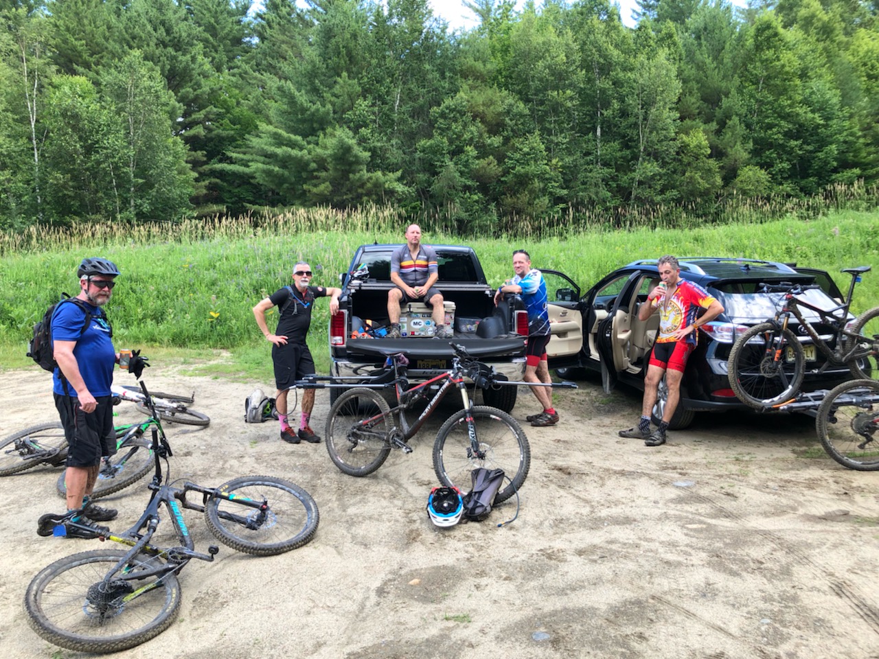
The Crew just after Moose Alley This was the only photo of us, taken by one of the guys after Moose Alley (and the jeep road climb) and before lunch, our next stop. We ate at the Tiki Bar in town, which is more like a pavilion or picnic area but it also had some food trucks. After lunch we went on a quest for Sidewinder, the legendary, ur-swoopy gravity trail.
We got a bit turned around looking for this one, but that meant we just rode more trails, and with the help of a few other riders we found the entrance. This was as fun as ever, but again I was a bit disappointed: Sidewinder is pretty hyped, and though it was fun it just seemed short, or smaller than I rememberd. (I later found out from other friends that they often do multiple laps on Sidewinder, to make it worthwhile. Live and learn.)
After Sidewinder we continued riding. I got separated, we met up again later and rode on, got semi-lost together, and eventually worked our way back to the cabin. Dinner downtown at the pub, then home and another deep sleep. Monday would be our last day.
We got up early and went back to the trail area with our new favorite trails, and though the other guys did a slightly longer ride, I basically did the same ride again: up, then down Black Bear, up again but only partway — they went to the top — and down Stormin’ Norman.
And with that our riding was over. We went back to the cabin, cleaned up, and hit the road by 11:00; I was home by 9:00. There was much group texting the next day, post-vacation work blues but I kept my mouth shut: Anne and I went blueberry picking Tuesday with Renee.
-
Going Up The Country
Heading out – next stop is Anne’s brother’s house, then tomorrow we’re going up to the Northeast Kingdom for a 3 day MTB weekend. Pics, stories to follow…