• Tag Archives native paths
  • Fun With Rasters

    I’ve been experimenting with raster data lately, photographing trail maps from Indian Paths of Pennsylvania and then digitizing them for use as map overlays in my project (I rough in the paths by tracing over them on the maps). This has worked really well, at least for when there is a path on the map — alternate paths are sometimes missing — but it came with a few problems:

    • The digitized maps (georeferenced to match my map and converted to GeoTIFF format) look great, but the first one I did weighed in at a whopping 27MB. Since I expect to generate at least a hundred of these, that’s a significant amount of disk space.
    • The maps start out as color photographs, and once they are in map form there is a lot of extraneous stuff that overlays (and blocks) the basemap beneath it.

    So, I came up with a workflow that brings in my map images while avoiding these problems:

    1. I start by taking a photo (with my phone) of the map in question, trying to get “nothing but map” in the shot.
    2. Using GIMP, I rotate and crop as necessary, then clean up the photo by making off-white sections white, despeckling, and increasing brightness/contrast. I then invert the colors, making it a B&W negative before saving.
    3. In QGIS I georeference the modified photo, using river confluences and other geographic features as my reference points. (I try for six or more “ground control” points to reference, and use the 2nd-order polynomial transformation to account for bent pages in the photo, though if the resulting transformation doesn’t look good I’ll try other options.)
    4. Finally I convert the resulting TIFF from RGB format (colors) to PCT (a sort of numeric) format, and save at half the original resolution.

    I can load the resulting raster as an overlay, and the raster pixels should be one of only two values (zero and one). I make the zero values transparent and the one values black, and now I have a very usable map overlay. The final GeoTIFF files average about 100KB each.

    This makes tracing the paths very easy, maybe too easy: I feel a temptation to take the paths as gospel, even though I have no real idea of either the original map accuracy or the accuracy of the georeferenced overlay. Then again, it is the information as given in the book, and that’s what I set out to capture. Anyway, it’s a good first step. I’ve done about a dozen so far.


  • Meniolagomeka

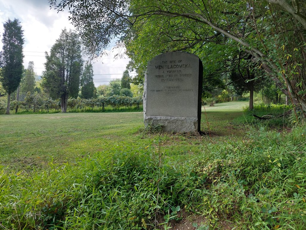
    Meniolagomeka Memorial Stone

    Meniolagomeka (“fat land in the midst of scarcity”) was a small Lenape village near what is now Kunkletown, on the banks of the Aquashikola Creek just north of Blue Mountain at Smith’s Gap. The Moravians had converted many in the village, and eventually founded a mission station there, but some time after the Walking Purchase the natives were evicted by the colonial authorities, and the Moravians relocated them to Gnadenhuetten (Lehighton). The actual location was pretty much forgotten for a century, until the Moravian Historical Society rediscovered it and put up this memorial marker.

    The village is not far off the route of one of the more iconic local bike rides — among my crowd anyway; it’s part of the old Gap Gallop century ride, crossing Blue Mountain at Little Gap and returning via Wind Gap a dozen or so miles further down the ridge — but I had no idea anything like this was here until recently. After the week of kitchen disasters we just had, Anne and I both needed a big ride, so even though the Blue Mountain route doesn’t really follow many native paths, and the Meniolagomeka site does not figure prominently in my Native Paths project, I thought it would be neat to do the ride, and make an effort to find the old memorial stone.

    So that was the ride we did on Friday, with our friend Dwight H.

    Our ride took us up Township Line Road, through Bath and Moore Township, and out to Danielsville via the little roads that run south of the mountain. Blue Mountain Drive was being repaved and was down to one lane the whole way to the top, but the construction guys gave us some traffic assistance (and an audience) for the climb. We regrouped at the top, then bombed down the hill, past the ski resort and made the right onto Smith Gap Road.

    The memorial is on a road called Chestnut Ridge Road, a turn off Smith Gap Road (and pretty much at Smith Gap). We turned off our route, spent some time admiring Aquashikola Creek, and then rode a few hundred yards up the hill and found the stone — it was at the edge of a field, on what looked like private property but close to and easily visible from the road. We stopped, took some pictures and paid our respects, and then continued on our way. (We heard thunder so we weren’t sticking around.)

    The rest of the ride was pretty uneventful, though we did get caught in a storm cell (a little cold rain actually felt good), and we also stopped at the “Snoopy Barn,” where Dwight took a few selfies. All told, we got in about 67 miles in just over seven hours. (I took about a mile off the beginning and end of the ride on my map, to preserve some privacy.)


  • Next Steps for The Native Paths

    So I have about a dozen left of the native paths to add to my database, in this first pass through Indian Paths of Pennsylvania (that book I’m following/analyzing/whatever). This is the pass where I go through the book from beginning to end, adding the basic info for each path to the database, adding the info about the start points and destinations, and generating the routes described in each chapter’s “For the Motorist” section.

    There are a few big pieces left to this project, which I think I can do all together in a second pass through the book:

    1. I need to document the relationships between the paths, as described for each path in the book (which is what required me to go through the book one first time: to get all the paths documented, before trying to map the relationships).
    2. I need to generate the actual footpath routes. This will probably be the most difficult and labor intensive task in the whole project, and I expect it will likely involve digitizing all the (low quality) maps in the book; it may also require trying to find primary sources, old deeds and land grants etc, and even after all that I expect I’ll have to live with a great deal of ambiguity in the routes.
    3. I’m not sure if I want to do this yet, but as I go through the book I may document any points of interest (landmarks, native towns that aren’t trail endpoints) that I haven’t already included.

    I’ve been thinking about the first part for a while, and have set up a separate bridge table in the database to capture these relationships; the table is set up with links to a subject path (the one that’s doing the referring) and an object path (the one getting referenced), and a link to another table with the list of possible relationships between them: intersections, alternate routes and spurs; aliases and alternate names; concurrencies (ie where the path shares some section of trail with another path); and the ever-popular “for more information see also.” I can add more relationships as I see the need.

    For the second task, I think I’ll want to use the maps in the book, even if it’s just to trace over. That means scanning the maps in some way without damaging the book (I may just photograph them with my phone), then georeferencing them and saving the result somewhere. I suspect I’ll end up with a pretty big set of raster data, and now need to consider how to do to organize it. Rasters are not something I have much experience with, so there will likely be a learning curve involved — I think I may put them in the database in some way.

    In terms of original research, my plan at the start was to use Indian Paths of Pennsylvania as my sole source — my project would be the book translated into GIS form — but I’ve already used other sources (e.g., Wikipedia, town websites) to flesh out histories and descriptions, and I think I’m seeing the book now as a condensation of other info, even if it’s just the author’s research files; the info in the book may have been “condensed,” oversimplified, to the point of vagueness, more exact versions of the trail descriptions exist somewhere. I really don’t want to get into actual archival research for this though, and it may just end up that if I dig really deep, I’ll only find that all the primary information is pretty vague too…

    Finally, that third task has me a bit stuck: I’d originally planned to only record the endpoints of the paths (as given in the book), and even called my points table “termini.” Now I’m looking to enter things like landmarks, known trail junctions — there are several places called “the parting of the ways” — towns that aren’t actually endpoints, and all sorts of other points of interest. I painted myself into a corner with that “termini” name, and even if it wouldn’t be too much of a stretch to stick these other points in the termini table, I may add a separate “points of interest” table, or at least add a column to the termini table to designate non-endpoints. (Maybe I’m overthinking this, I could easily find the endpoints and non-endpoints within a mixed table, just by using simple searches.)

    This kind of gets to what I want my native paths data to eventually look like. Many of these landmarks and points of interest are likely to be nodes in a trail network (just like the endpoints), so I am back to thinking they should all be part of the same table. I also expect that I’ll have trail segments from node to node, and my final paths will be lists of trail segments from start point to end point, so my final product will not look much like what I’m building now.

    Well, I still have some time to think about it.


  • Indian Paths Update

    I’m still cruising along on this project: I’ve got just over 110 paths in the database (of maybe 150 total), about 130 towns or other path endpoints, and 92 motorway routes. I have added no actual paths yet, but the motor routes are starting to look like a real network.

    My current plan is to parse the book three times: once (this time around) to capture the paths, path endpoints, and motor routes; once (the final, and probably most difficult, round) to try and develop the original foot paths; and in between these rounds I will go through the paths/chapters and try to capture all the cross-references between them.

    I noticed early on that there were a lot of things like “this is an extension of that other path,” “so-and-so path also goes by this name,” “this path intersects with these others,” and such like throughout the text; the path descriptions are festooned with these kinds of cross-references.

    (I also finally picked up on the fact that paths without a path/chapter number are not actually part of the previous chapter, but are basically “chapterless,” just the next path name in alphabetical order. They act sort of as placeholders, the alternate names of other, more fully fleshed-out paths — that is, more cross-references.)

    I want to hold on to all this cross-reference information in my database, so I set up a bridge table to work something like a resource description framework, with the referring path as the subject, the referenced path as the object, and for the predicate I would use a description of the relationship type, such as “[subject path] is a continuation of [object path],” “[object path’s name] is an alternate name for [subject path],” “for more info see [object],” and so on. I now have all of this set up and ready to go, but before filling it in with information I want to have all the paths already in the database. Soon…

    Meanwhile, the details, of each path or town I add, have all been real eye-openers. I often do a little internet research on each town, or village, or Native name I come across, and each bit of info, each piece of the puzzle is another portal into that era.


  • Native Paths Update

    I kept at it, and am now about a quarter of the way through the trails — the motorway parts, at least — in my Indian Paths of Pennsylvania project. I have a pretty good idea of how the book is organized now, and came up with a pretty decent workflow that gets me through a single path in just under an hour. I do one or two a day. It’s pretty easy to get absorbed, trying to find the tiny old roads and landmarks based on their descriptions in the book, and I’ve been totally sucked into the history of that Colonial-Revolutionary era. (I picked up Mason & Dixon again, since it goes right through the middle of that time and place.)

    I also think there will be some epic rides this summer, based on these routes — I’ve been drooling over some of the scenes I see in Google Street View.


  • Foiled Again!

    I have a love-hate relationship with Paul A. W. Wallace’s Indian Paths of Pennsylvania. I love reading the individual chapters on each path — their descriptions, and the accounts of them in the letters and diary entries of early Colonial explorers, but any hard look at the specifics and the trails themselves become frustratingly vague. This is all the more frustrating because the information looks specific and authoritative enough, until you take that close look…

    Some of this is because the original information is vague — nobody was tracking their steps with a GPS back then — so the actual trail location is not perfectly known, and partly it’s because the trails themselves are long gone (though some are at least partly followed by modern roads), so it’s hard to search them out without trespassing, but there also just seems to be some missing ingredient needed to define a trail network.

    A few years ago I thought that this last part could be solved with a little bit of GIS detective work, so I started a QGIS project to define the trails and see about building a network, but I sort of ran out of steam — I basically foundered on the vagueness of the trail descriptions. I did one or two in the Lehigh Valley, and realized that the sleuthing needed was a lot more laborious than simple data entry, and the project languished after those first few paths.

    I was thinking about all this again recently, and realized that there is a critical first step I ignored: the book serves primarily as an automotive guide, with detailed instructions for driving in the vicinity of each path. I also thought that if I broke the task down to a set of database tables, I could link these auto routes to their various paths and book chapters . (Some trail chapters actually describe multiple trails and subtrails, while some motorway descriptions continue across multiple chapters, so many-to-many relationships abound but that’s what databases are for. Furthermore, most of the trail chapters have a start and an endpoint, yet more data I can use to cross reference.)

    This scheme fell apart within the first few trails. The very first trail, the “Allegheny Path,” has Philadelphia as the start point and “Pittsburg and Kittanning” as the endpoint — so which is the endpoint? Apparently neither, because the trail is only described as far as Harrisburg; the “Allegheny Path” chapter ends with references to several other trails (different chapters, in other words) heading West from Harrisburg as possible continuations. So OK, I can deal with this: my endpoints are really Philadelphia and Harrisburg, and I’ll stuff the rest of the info into my “description” column. (There is a second path listed in that first chapter, but it is little more than a historical aside and a reference to another path/chapter. This is going to get tricky.)

    Luckily the motorway for the Allegheny Path is easy to follow. I used an open routing plugin to follow along a bunch of control points, and voilá I had my linestring. This ain’t so bad!

    The very next chapter, I ran into motorway difficulties: the route description made no sense. Either the routes were not prepared with adequate ground-truthing (unlikely, though I was starting to feel uncharitable), or the roads (and their designations) had changed at some point in the 55 years since the book came out. This seems the more likely explanation, since I-80 goes right through the area in question, was only finished in 1970, and probably changed a lot of things in its wake. I actually found the Wikipedia article on the Bald Eagle Creek Path more useful.

    So I’m back to deciphering and making judgement calls rather than strictly converting the information from one format to another, even for these road descriptions. I didn’t expect this project to be done in an afternoon, or even a week or so, but “going to take forever because I’m not really working on it” is now closer to my expectation.

    (Note: I found that someone already took these paths and put them into a GIS, but it’s on PA-Share and that’s proved difficult to work with — and deliberately limited, unless you pay — so far. We’ll see…)